
Mapping the Croplands
ICRISAT’s high-resolution map reveals where India’s farms depend on irrigation, and where rainfall still rules

Ajeet Singh
India’s farming landscape is fundamentally divided between irrigated and rainfed systems. This divide shapes cropping choices, productivity, resilience to climate shocks and long-term sustainability.
Yet, despite its importance, most national datasets remain too coarse to capture these distinctions meaningfully. At resolutions of 30 metres or worse, critical variations - such as mixed irrigation practices, smallholder field boundaries and seasonal shifts - are often blurred or missed altogether. Hyderabad-based International Crops Research Institute for the Semi-Arid Tropics (ICRISAT) has unveiled a high-resolution national map that clearly distinguishes irrigated and rainfed croplands across India, offering an unprecedented field-level view of agricultural water dependence.
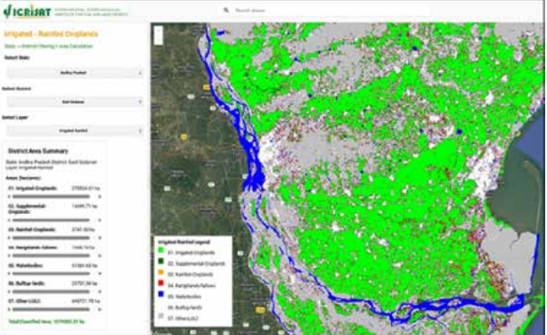
ICRISAT’s new dataset changes that equation. Developed for the 2024- 25 agricultural year, the map uses 10-metre resolution Sentinel-2 satellite imagery, analysed through dense timeseries data and validated with field observations. By tracking seasonal crop behaviour over time, researchers were able to differentiate irrigated and rainfed croplands with far greater precision than previously possible. The work builds on ICRISAT’s earlier regional mapping efforts in South Asia, which relied on coarser Landsat-8 (30 m) and MODIS (250 m) datasets. According to ICRISAT Director General Dr Himanshu Pathak, the timing of the map is especially significant. “As India moves steadily towards sustainable water use under initiatives like the National Water Mission and More Crop Per Drop, agricultural water budgeting is becoming unavoidable,” he said. “This map provides decision-makers with a robust evidence base to guide policy and investment.”
Accuracy is a key strength of the dataset. ICRISAT estimates around 90 percent accuracy in cropland mapping and nearly 70 percent accuracy in distinguishing irrigated from rainfed areas - a notable achievement given India’s fragmented landholdings and varied farming systems. The fine spatial resolution also captures transitional zones and mixed practices that are typically invisible in nationallevel datasets.
For policymakers and planners, the implications are far-reaching. Dr Stanford Blade, Deputy Director General - Research & Innovation at ICRISAT, noted that the dataset can support decision-making at multiple governance levels. “From village panchayats to central ministries, this map helps stakeholders better understand India’s semi-arid and irrigated landscapes and design targeted strategies to improve wateruse efficiency,” he said.
Equally important is accessibility. Rather than confining the dataset to specialists, ICRISAT has made the maps available through a userfriendly Google Earth Engine application. Users can explore district-level maps, view class-wise statistics and interact with the data without advanced geospatial expertise - a move that significantly broadens its potential impact.
Dr Muralikrishna Gumma, Principal Scientist for Geospatial and Big Data Sciences at ICRISAT, emphasised the dataset’s analytical value. “It offers a stronger foundation for water budgeting, drought and risk monitoring, crop planning and yield modelling,” he said. “Agencies can track changes in irrigated areas, identify vulnerable rainfed regions and design interventions that reflect on-ground realities.”
As climate extremes intensify and competition for water grows sharper, India’s agricultural future will depend increasingly on precise, actionable data. ICRISAT’s high-resolution cropland map does not merely chart fields on a screen - it provides a practical tool for building resilience, improving efficiency and grounding agricultural policy in evidence rather than approximation.
RNI No: DELBIL/2024/86754 Email: [email protected]